


•Downpours have caused flash-flooding in the South East and the Midlands
•Market Bosworth in Leicestershire endured 61mm of rain yesterday
•The average rainfall for July was 80mm according to experts
•Met Office has increased weather warning to amber
•It urged residents in the Midlands and north of England to be prepared
The Met Office has issued an ‘amber warning’ following a night of torrential rain, thunder and lightning across the UK and is warning residents in the Midlands and north of England to prepare for flooding.
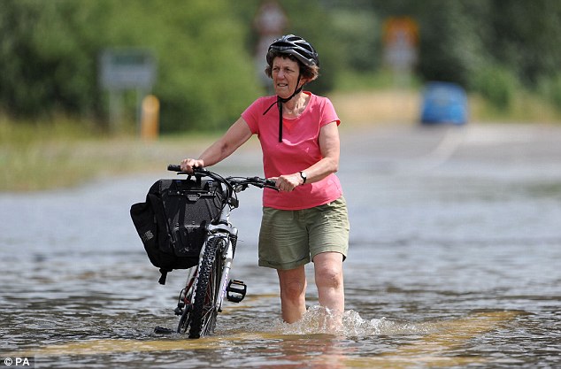
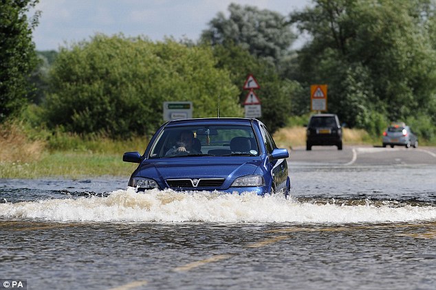
The heavy downpours have already caused flash-flooding in the South East and the Midlands, with more expected today as the rain spreads north and west.
In just four hours yesterday evening Market Bosworth in Leicestershire endured 61mm of rain and many other areas saw between 20mm and 30mm, with similar amounts forecast today.
This compares with an average rainfall of around 80mm for the whole month of July, weather experts said.
The Met Office has increased its weather warning level to ‘amber’, the second of three levels, and told people living in the Midlands and north of England to be prepared for storms likely to cause surface water flooding and disruption today.
The Environment Agency has also issued 32 flood alerts in the same areas, and two more serious flood warnings near Rochdale and Sheffield as river levels rise.
Forecaster Tom Tobler, from MeteoGroup, said there is a chance of being hit by heavy downpours almost anywhere in the UK today.
He said: ‘The torrential rain and thunderstorms will move into north England and into Scotland, as well as across to the South West and South Wales.
‘Between 20mm and 30mm could fall, some of it on top of areas which might have already seen showers, so there is a continued risk of flash-flooding.
But you could catch a heavy shower pretty much anywhere in England and Wales, but the South East should remain mainly dry and up to 25C.’
Heavy rain overnight caused road closures and tricky driving conditions in the North East.
In Newcastle, the Scotswood Road close to the River Tyne was closed due to ‘floodwater and silt’, the city council said.
Durham County Council tweeted: ‘The heavy rain overnight has left standing water across the county’s roads. Please drive safely if you’re out today.’
It comes after a glorious run of baking sunshine in July which has turned increasingly unsettled over the last week.
The weather is likely to remain changeable over the next few days.

Dramatic: A lightning bolt strikes the Eiffel Tower in Paris during one of the biggest storms ever to hit Paris
Tonight clear spells will gradually give way to increasing amounts of cloud from the south-west
together with showers.
The showers are likely to be heavy and thundery in places, particularly in the west.
However, East Anglia and the far southeast of England are likely to escape largely dry.
Northern Ireland will also be cloudy at times with showers.
In Scotland, any rain in the north will soon ease, leaving drier conditions for many with broken
cloud but showers are likely over southern parts later on.
After a cloudy start in places tomorrow, much of the UK will see a mixture of sunny spells and showers through the day.

Participants take part in The Sumo Run in Battesea Park, west London. The Sumo Run is an annual 5km charity fun run around the park in inflatable Sumo suits
The showers are likely to be frequent and heavy over many western parts of the UK together
with much of Scotland with localised thunderstorms developing too.
However, parts of eastern and north-east England could also see a few heavy, thundery showers during the afternoon.
Turning sunnier and dry near to English Channel coasts later in the afternoon.
Tuesday will be a rather cool day with any sunny spells over England and Wales giving way to cloudier skies from the west together with some rain in places.
On Wednesday, many areas are likely to be rather cloudy with some rain at times but northern Scotland and south-east England will be drier and brighter.
Holidaymakers have been warned after a large landslip hit a Dorset coast close to where a young woman was killed last summer.
West Dorset lifeguards say there is a ‘dangerous overhang’ at the cliff top in East Cliff between West Bay and Freshwater.
Portland Coastguard said the landslip was about 450 metres from where Charlotte Blackman was killed at Burton Bradstock last July.
The beach has now been closed and warning signs put up. The Jurassic coast is prone to landslip.
The Dorset Countryside Coastal Ranger team are concerned that people are not aware of the dangers of sunbathing at the base of the cliffs.
Senior ranger John Hayes said he was on the beach before it was closed off and saw a young girl ‘playing at the base of the cliff with 60 metres of rock above her head and her parents watching on’.
Mike Branagan, of Portland coastguards in Dorset, said: ‘People should be aware of the cliffs and not linger underneath them.’
Last July Charlotte Blackman, 22, from Heanor, Derbyshire, was killed as she walked directly beneath the cliffs moments before it collapsed.
Leave a reply